[UPDATE 2011/09/24: UARS has crashed to Earth, and NASA tweeted the aftermath]
NASA’s Upper Atmosphere Research Satellite has begun to fall to Earth and the space agency is pretty confident that UARS will not do any damage when it makes touchdown in the next few hours.
RT @neiltyson Earth, in orbit, plows through several hundred tons of meteors per day. So we’ll all survive Friday’s 6-ton falling satellite
— NASA (@NASA) September 23, 2011
But if you are curious (or just a bit worried) then you can download this Google Earth layer which says it shows the location of Earth’s satellites’ in realtime (we’ll see on Saturday how accurate it is). If you don’t have Google Earth then you can download it here.
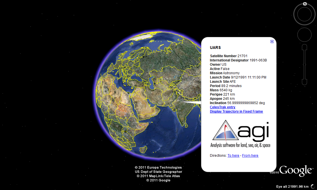
To view UARS’s location download the KMZ file and unclick everything. Expand the “Inactive Satellites” link and scroll down to “US” then scroll down again and select UARS. Now click on the text link that reads UARS to see the expected location of the satellite.

Click the image to enlarge
According to the Google Earth Layer it, “visualizes all earth orbiting objects tracked by the United States Strategic Command (USSTRATCOM) using the satellite database processed by Analytical Graphics, Inc. using the Dynamic Geometry Library. All satellites are tracked in real-time and updated every 30 seconds.
USSTRATCOM has been tracking space objects since 1957 when the Soviets opened the space age with the launch of Sputnik I. Since then, they have recorded more than 26,000 space objects orbiting Earth. There are currently more than 12,000 man-made orbiting objects, the rest have re-entered Earth’s turbulent atmosphere and disintegrated, or survived re-entry and impacted the Earth. The space objects now orbiting Earth range from satellites weighing several tons to pieces of spent rocket bodies weighing under 10 pounds. About 3,000 space objects are operational satellites, the rest are space debris, retired satellites and rocket bodies left over from launches.”
Alternatively download DroidSat, which uses data from the satellite tracking sites celestrak.net and amsat.org to show the realtime location of dozens of satellites orbiting the Earth.
Once you have downloaded the app you can track UARS by,
- Clicking the Menu button and then choosing Update Tiles.
- Next, scroll down to and select science.txt; this will download a list of science satellites.
- Finally use the dropdown menu to pick UARS.
The app will now tell you where the satellite is expected to be (hopefully it won’t be overhead).
The Weather Channel is also live-streaming the satellite’s location
Live Video streaming by Ustream
The space agency’s latest release says,
“As of 7 p.m. EDT on Sept. 23, 2011, the orbit of UARS was 90 miles by 95 miles (145 km by 150 km). Re-entry is expected between 11 p.m. Friday, Sept. 23, and 3 a.m., Sept. 24, Eastern Daylight Time (3 a.m. to 7 a.m. GMT). During that time period, the satellite will be passing over Canada, Africa and Australia, as well as vast areas of the Pacific, Atlantic and Indian oceans. The risk to public safety is very remote.”