Ireland’s Minister for Justice has a few concerns with Apple’s new iOS6 map application. The main one being that iOS6′s new mapping app identifies Airfield Garden, a working farm in a residential area, as an actual airport.
Minister Alan Shatter described his confusion of the designation, saying;
“I am surprised to discover that Airfield, which is in the centre of my constituency in Dundrum, has, in Apple’s new operating system iOS 6 maps application, been designated with the image of an aircraft.
Airfield, a 35 acre estate with working farm, formal gardens and café is of course a famous and immensely popular, important local amenity. “
In a statement released today he warns that describing the location as an airport could be dangerous to pilots and locals, “Clearly the designation is not only wrong but is dangerously misleading in that it could result in a pilot, unfamiliar with the area, in an emergency situation and without other available information, attempting a landing.”
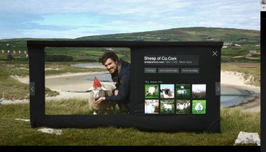
The Minister did offer some alternative icons for Apple, which his department is arranging contact with; such as “a cow, a goat, a sheep, a flower or any indeed other type of plant as Airfield operates a nursery.”
“An aircraft is an entirely inappropriate flight of imagination,” he added, with the pun probably intended.
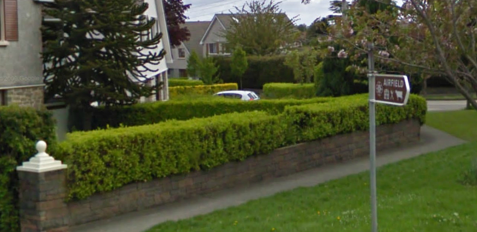
The Minister will be happy to see that Google Maps uses a nice tree to identify the location.
The location, which has its own website (@airfieldfarm | Facebook), is currently undergoing renovations and describes itself as “city farm and formal gardens situated on a thirty-five acre estate in Dublin.” The site’s objectives don’t list an airport as among its goals.
This isn’t the first time that mapping applications have made mistakes in Ireland; Google Maps still reports that U2′s scrapped tower is located in Dublin.


[...] is a picture via Sociable.co. Apple has fixed the change and I am guessing that they will have to manually override some of [...]
[...] fact, Ireland’s Minister for Justice, Alan Shatter, said Apple’s new maps app in iOS 6 is “dangerously misleading.” iOS 6 labels Airfield Garden as an [...]
[...] Na Inglaterra, por exemplo, alguns usuários enviaram para a BBC fotos do aplicativo que mostram museus dentro de rios, imagens borradas, presença de locais estranhos e nomes trocados. Na Irlanda, o aplicativo da Apple identifica uma fazenda chamada AirField Garden como um aeroporto, segundo informa o The Sociable. [...]
[...] Na Inglaterra, por exemplo, alguns usuários enviaram para a BBC fotos do aplicativo que mostram museus dentro de rios, imagens borradas, presença de locais estranhos e nomes trocados. Na Irlanda, o aplicativo da Apple identifica uma fazenda chamada AirField Garden como um aeroporto, segundo informa o The Sociable. [...]
[...] new operating system iOS 6 maps application, been designated with the image of an aircraft,” Minister Alan Shatter was quoted saying in the Sociable. “Airfield, a 35-acre estate with working farm, formal gardens and [...]
[...] Ireland’s Minister for Justice expressed concern that the new Apple maps identify a working farm in a residential area of suburban Dublin as an airport, a potential hazard for pilots. [...]
[...] Na Inglaterra, por exemplo, alguns usuários enviaram para a BBC fotos do aplicativo que mostram museus dentro de rios, imagens borradas, presença de locais estranhos e nomes trocados. Na Irlanda, o aplicativo da Apple identifica uma fazenda chamada AirField Garden como um aeroporto, segundo informa o The Sociable. [...]
[...] Ireland’s Minister for Justice expressed concern that the new Apple maps identify a working farm in a residential area of suburban Dublin as an airport, a potential hazard for pilots. [...]
[...] Ireland’s Minister for Justice expressed concern that the new Apple maps identify a working farm in a residential area of suburban Dublin as an airport, a potential hazard for pilots. [...]
[...] Ireland’s Minister for Justice expressed concern that the new Apple maps identify a working farm in a residential area of suburban Dublin as an airport, a potential hazard for pilots. [...]
[...] Ireland’s Minister for Justice expressed concern that the new Apple maps identify a working farm in a residential area of suburban Dublin as an airport, a potential hazard for pilots. [...]
[...] Ireland’s Minister for Justice expressed concern that the new Apple maps identify a working farm in a residential area of suburban Dublin as an airport, a potential hazard for pilots. [...]
[...] http://sociable.co/meme/thats-not-an-airport-its-a-farm-irish-minister-for-justice-is-not-happy-with… [...]
[...] Ireland’s Minister for Justice expressed concern that the new Apple maps identify a working farm in a residential area of suburban Dublin as an airport, a potential hazard for pilots. [...]
[...] to problems with showing cities or buildings in the wrong place. Another glaring problem is the showing of an airport where none actually exists in Ireland. For some, that can be considered as offensive. Apple needs to be careful to not offend [...]
[...] possibly the most egregious Apple mapping error may be the one that a foreign governmental official has discovered. “Ireland’s Minister for Justice has a few concerns with Apple’s new iOS6 map [...]
[...] THE SOCIABLE, (página consultada a 21 de Setembro de 2012). “That’s not an airport, it’s a farm – Irish Minister for Justice considers Apple’s iOS 6 Maps dangerous” [em linha]. Disponível em: URL: http://sociable.co/meme/thats-not-an-airport-its-a-farm-irish-minister-for-justice-is-not-happy-with… [...]
[...] The news caps off a difficult, although not terrible, year for Apple. The company lost some significant top executives and it lost much of its hard earned credibility with the release of its faulty Maps app. [...]